

 همایش های بین المللی
 مجموعه همایش های بین المللی ISPRS، مهر ۹۸
مجموعه همایش های بین المللی ISPRS، مهر ۹۸ برگزار می شود.
به گزارش پایگاه خبری مهندسین نیوز _ مرجع اخبار نظام مهندسی کشور،سطح برگزاری: بین المللی
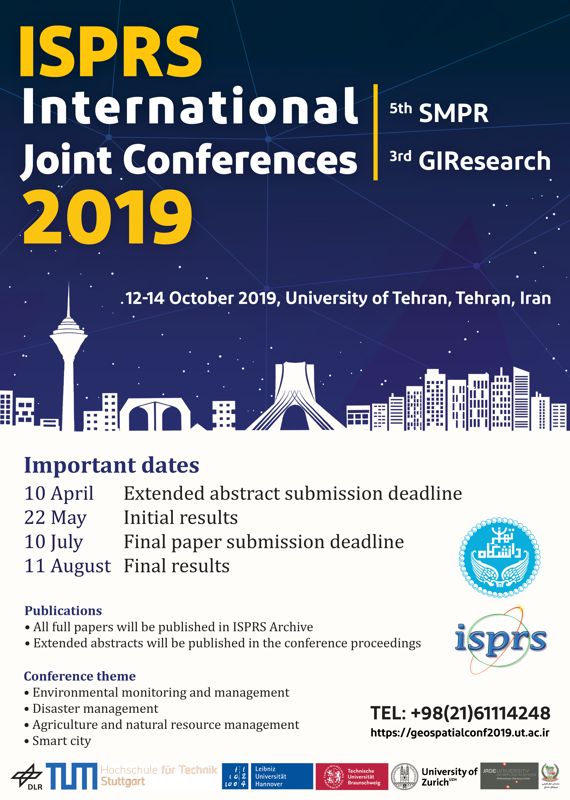
مجموعه همایش های بین المللی ISPRS
مجموعه همایش های بین المللی ISPRS، مهر ۹۸
برگزار کننده: دانشگاه تهران
امکان ارسال مقاله: بله
مکان برگزاري: تهران – دانشگاه تهران
تاريخ برگزاري: ۲۰ الی ۲۲ مهر ۱۳۹۸
آخرين مهلت ارسال چکیده مقالات: ۲۱ فروردین ۹۸
اعلام نتایج داوری چکیده مقالات: ۱ خرداد ۹۸
آخرين مهلت ارسال اصل مقالات: ۱۹ تیر ۹۸
اعلام نتایج داوری اصل مقالات: ۲۰ مرداد ۹۸
دبیر علمی کنفرانس: دکتر محمد سعادت سرشت
دبیر اجرایی کنفرانس: دکتر پرهام پهلوانی
تلفن تماس با دبيرخانه: ۶۱۱۱۴۲۴۸-۰۲۱
وب سايت همايش: geospatialconf2019.ut.ac.ir
ایمیل: geospatial.conf[at]ut.ac.ir


مجموعه همایش های بین المللی ISPRS
Acquisition, storage, modeling and analysis of spatial data and information
Geospatial Information Systems
- Multi-dimensional modelling, analysis and visualization
- Spatial decision support systems and multi-criteria decision making
- Geospatial simulation and modeling
- Spatio-temporal data mining and knowledge discovery
- Spatial optimization and computational intelligence
- Spatial data quality and uncertainty assessment
- Location-based services, geospatial services and real-time applications
- Indoor and outdoor navigation, routing and way finding
- Spatial movement data analysis
- Geospatial information for smart cities and smart environment
- Geosensors networks and sensor Web
- Cartography, generalization and multi-scale representation
- Spatial cognition and spatial linguistics
- Spatial semantics and spatio-temporal ontologies
- Ubiquitous geospatial information systems
- Volunteered geographic information, crowdsourcing and public participatory GIS
- Spatial data structures and algorithms
- Spatial Big data management
- Building information management (BIM)
- Spatio-temporal data modeling, analysis and acquisition techniques
- Land administration, spatial data infrastructures and spatially-enabled government
- Interoperability and standards
Remote Sensing and Photogrammetry
- Airborne, terrestrial and mobile mapping
- Unmanned vehicle systems for geomatics
- Laser scanning for 3D surveying and mapping
- SAR image analysis, modeling and techniques
- POL and POLInSAR techniques and applications
- Digital terrain modeling and analysis
- Sensors and methods of DEM generation
- Feature extraction/selection and dimension reduction in hyperspectral images
- Image segmentation, object detection and recognition
- Target detection and unmixing in hyperspectral images
- Feature extraction and information retrieval from SAR and hyperspectral images
- Image and spatial data fusion
- Close range photogrammetry
- ۳D reconstruction and point cloud processing
- Virtual and augmented reality
- Tomography and 3D mapping
- Satellite oceanography
Geodesy
- Geodetic sensors and 3D measurements
- Relative satellite positioning
- Recent advances in modeling time-varying gravity field
- Geodetic reference frames
- Advances in earthquake source imaging using geodetic and seismic data
- Geodesy on large construction: monitoring of structures and system analysis
- Imaging geodesy and GPS for tectonic and non-tectonic deformation analysis
- Modeling atmospheric effects in geodetic observations
- Sensor technology and geodetic meteorology
Spatial information and earth observation for environmental monitoring, natural hazards, and disaster management
- Earth observation missions for monitoring environmental changes at local, regional and global scales
- Monitoring and modeling land use and land cover changes
- Remote sensing and GIS to support the emergency management
- Geoinformation to support early warning in cases of natural hazards
- Remote sensing of changes in snow and ice, frozen ground, ice sheets and glaciers and arctic water sea ice
- Photogrammetry and remote Sensing for dynamic vulnerability and recovery monitoring
- Desertification, deforestation, flood, earthquake, landslide vulnerability assessment
- Climate-induced hazards mapping and vulnerability assessment
- Modeling and analyzing of impacts from sea level rise
- Integration of remote sensing and GIS for predicting, monitoring and responding to hydro-meteorological and geophysical extremes
- Spatiotemporal modeling of landscape dynamics
- Quality assurance for environmental change databases
- New earth observation systems for natural hazard monitoring
- Geosensor networks for environmental monitoring
- UAV systems for hazard mapping and damage assessment
- Laser scanning for indoors and outdoor mapping and search and rescue simulations
- Web based multidimensional GIS for disaster risk management
- Multi-sensor fusion/integration for monitoring marine disasters
- Integrated coastal zone management (ICZM) modeling and monitoring
- Mobile mapping for transportation emergency response
- New geospatial technologies in early warning, forecasting and monitoring of natural hazard chains
- Public participation GIS for disaster preparedness and planning
- Foggy weather/heavy rain, impact on quality of life (e.g., car accidents)
- Red tide, impact on marine life and policy management
- Sand twisters and rigorous winds
- Geospatial modeling of environmental and air pollution
- Geospatial big data for environmental modeling
- Energy management using geospatial modeling
- Precise agriculture using remote sensing and GIS
- Terrestrial and sea surface thermal mapping
- Natural resource management using remote sensing and GIS integration
- Oil and gas potential mapping using remote sensing and GIS
- Rapid mapping for environmental applications and disaster management
- Mapping of settlement patterns for urbanization monitoring
- Agricultural mapping and monitoring
- Vegetation and crops monitoring and growth
- Forest classification and monitoring
منبع: کنفرانس یاب
مشاهده منابع آزمون نظام مهندسی
مباحث آزمون نظام مهندسی تاسیسات برقی


لیست نظرات